
 NEMBA mountain bike rides - The New England Mountain Bike Association (NEMBA) a recreational trails advocacy organization with 27 chapters throughout New England and about 5,000 members NEMBA Rides by State Connecticut Maine Massachusetts New Hampshire Rhode Island Vermont NEMBA alphabetical list of rides Abrams Rock Adams Farm Ames Nowell State Park Bare Cove / Great Esker Beaver Brook North Beebe Woods / Peterson Farm… Continue reading NEMBA mountain bike rides
  New Hampshire’s Northern Rail Trail - The Northern Rail Trail follows a section of Boston & Maine’s abandoned railway heading southeast from Lebanon, New Hampshire that once went to Boston, stretching across the Mascoma Valley in central New Hampshire. The 23.8-miles between Lebanon and Grafton follow the Mascoma River and passes beside Mascoma Lake. The Merrimack County Section is now connected… Continue reading New Hampshire’s Northern Rail Trail
 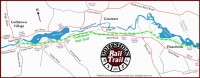 Goffstown Rail Trail - The 5.5 mile Goffstown Rail Trail follows the former Boston & Maine railroad right of way from the Piscataquog River near the Main Street bridge in Goffstown, New Hampshire to the Manchester city line near in Pinardville. Running parallel to Mast Road and the Piscataquog River, eventually the Goffstown trail will connect to Manchester’s Piscataquog… Continue reading Goffstown Rail Trail
  Manchester: Rockingham Recreational Trail - The unpaved 28-mile Rockingham Recreational Trail follows the former Portsmouth Branch of the Boston and Maine Railroad. The western end of the trail begins behind the Rite-Aid on Mammoth Rd. and continues along the shore of Massabesic Lake to Newfields.… Continue reading Manchester: Rockingham Recreational Trail
  Nashua River Rail Trail - The Nashua River Rail Trail follows the former Hollis branch of the Boston and Maine Corp. railroad for 11 miles through the towns of Ayer, Groton, Pepperell and Dunstable, with a 10-foot wide paved surface for the entire length. The trail travels along a varied and scenic landscape, and no motorized vehicles are allowed. The… Continue reading Nashua River Rail Trail
  Ammonoosuc Rail Trail - The Ammonoosuc Rail Trail is a 19 mile gravel and dust path following the Ammonoosuc River in New Hampshire. The trail starts at Central Street in Woodsville and ends at Industrial Park Road in Littleton. Route at RideWithGPS View and print map GPX file TCX Course
Trailink.com

- Ammonoosuc Rail Trail 19 miles Ballast, Dirt, Gravel, Sand
- Appel Way Trail 1.3 miles Asphalt
- Ashuelot Rail-Trail 21.2 miles Ballast, Cinder, Crushed Stone, Dirt
- Black Pond Trail 0.8 miles Dirt
- Bobby Woodman Rail Trail 1.7 miles Dirt, Gravel
- Cheshire Rail Trail (Cheshire Branch Rail Trail) 32.8 miles Ballast, Cinder, Dirt
- Common Pathway 6.5 miles Asphalt, Crushed Stone
- Conway Branch 21 miles Ballast, Gravel
- Cotton Valley Rail-Trail 8.1 miles Crushed Stone
- Derry Rail Trail 3 miles Asphalt
- Dover Community Trail 3.8 miles Asphalt, Crushed Stone
- Farmington Recreational Rail-Trail 6 miles Ballast, Cinder, Dirt, Gravel, Sand
- Fort Hill Branch Rail-Trail 8.9 miles Ballast, Cinder, Dirt, Gravel, Sand
- Franconia Brook Trail 7.2 miles Ballast
- Franconia Notch Recreation Path 8.8 miles Asphalt
- Goffstown Rail Trail 5.5 miles Dirt, Grass, Gravel, Sand
- Granite Town Rail-Trail 3 miles Ballast, Cinder, Dirt, Grass, Gravel, Sand
- Guinea Pond and Flat Mountain Trails 11.5 miles Ballast, Dirt, Grass
- Heritage Trail (Manchester) 0.9 miles Asphalt
- Hillsborough Recreational Rail Trail 7.8 miles Crushed Stone, Dirt
- Hooksett Rail Trail 1.75 miles Gravel
- Jonathan Daniels Trail 0.9 miles Crushed Stone
- Keene Industrial Heritage Trail 1 miles Asphalt
- Lake Winnisquam Scenic Trail 5.3 miles
- Lincoln Woods Trail 2.7 miles Ballast
- Londonderry Rail Trail 3.1 miles Asphalt
- Mason Railroad Trail 6.7 miles Ballast, Gravel, Sand
- Monadnock Branch Rail-Trail 7.2 miles Asphalt, Gravel
- Nanamocomuck Trail 12 miles Ballast
- Nashua Canal Trail (Mine Falls Park) 6.05 miles Asphalt, Dirt, Grass, Gravel
- Nashua Heritage Rail-Trail 1.3 miles Asphalt
- Nashua River Rail Trail 12.3 miles Asphalt
- New Boston Rail Trail 4.5 miles Dirt
- Northern Rail Trail 58 miles Cinder, Crushed Stone, Dirt, Grass, Gravel
- Oliverian Brook Trail 3.5 miles Dirt
- Peanut Trail 1.5 miles Cinder
- Piscataquog Trail 2.1 miles Asphalt
- Presidential Range Rail Trail 18 miles Gravel
- Ramblin Vewe Farm Trails 5 miles Dirt, Grass
- Rob Brook Trail 2 miles Dirt, Gravel
- Rockingham Recreational Rail Trail (Fremont Branch) 16.5 miles Dirt, Sand
- Rockingham Recreational Rail Trail (Portsmouth Branch) 26.5 miles Crushed Stone
- Rocky Branch Trail (NH) 9 miles Dirt, Gravel
- Salem Bike-Ped Corridor 0.15 miles Asphalt
- Sawyer River Trail 7.5 miles Ballast, Dirt, Grass, Sand
- South Manchester Rail Trail 0.89 miles Asphalt
- Stevens Rail Trail 1.3 miles Dirt, Gravel
- Sugar River Trail 9.8 miles Ballast, Cinder, Sand
- Trestle Trail 1 miles Dirt
- Upper Coos Recreational Trail 10.5 miles Ballast, Cinder
- Blackmount Rail Trail 5 miles Cinder, Gravel, Woodchips
- Warren to East Haverhill Railroad Grade Trail 10.7 miles Dirt
- West Milan Trail 4.5 miles Gravel
- Wild River Trail 15 miles Dirt, Gravel
- Windham Rail Trail 4.1 miles Asphalt
- Winnipesaukee River Trail 5.1 miles Crushed Stone, Dirt
- WOW Trail 1.3 miles Asphalt
- York Pond Trail 6.5 miles Dirt
NH State Parks
- Northwood Meadows State Park Northwood, 5.5 miles
- Odiorne State Park Rye
- Pawtuckaway State Park Raymond/Nottingham 15 miles
- Pilsbury State Park , Washington 51-mile trail
- Pisgah State Park Chesterfield, Hinsdale, Winchester 13,500 acre state park
- Rockingham Recreational Trail Manchester, 18 miles
- UNH Bike Trails Durham
- Bear Brook State Park, Allenstown NH, map to park. 10,000 acre park with varied terrain. Bear Brook Trails Map
- Franconia Notch State Park (Franconia Notch Bike Path) map to park features Flume Gorge, The Old Main of the Mountain Profile, Profile Lake, Boise Rock, The Basin, Cannon Mountain Aerial Tramway, and Echo Lake. Franconia Notch Map
- Hopkinton-Everett Reservoir Dunbarton: 8,000 acres with 20 miles of advanced intermediate to expert terrain. trail map
- Weeks State Park, Lancaster (map to park). Views of the Presidential Range of the White Mountains, the Green Mountains of Vermont, the Kilkenny Range, the Percy Peaks, and the upper Connecticut River Valley.
- Moose Brook State Park, Gorham: four-mile loop within the park with advanced terrain. Map to park .
- Northwood Meadows State Park, (map to park)Northwood: beginner and family riding around Meadow Lake. Trail Map
- Odiorne Point State Park, Rye: (map to park) paved recreational path and unpaved trails throughout the park.Odiorne Point State Park Trail Map
- Pawtuckaway State Park, Nottingham (map to park) 5,600 acres with mixed terrain Pawtuckaway Trail Map
- Pillsbury State Park, Washington (map to park) links to the 51 mile Monadnock-Sunapee Greenway trail. Pillsbury State Park Hiking Map
- Pisgah State Park, Winchester/Chesterfield/Hinsdale (map to park) The largest state park in New Hampshire with intermediate and advanced trails for mountain biking throughout. Pisgah State Park Trail Map
